Whenever an organization decides to get an app for Dynamics 365, the CRM System Admin is the first person who needs to understand and prep the system for the new solution.
A geo-analytical map visualization solution like Maplytics helps organizations to visualize CRM data on a map for geographical analysis, see nearby service cases, optimize routes, and manage sales territories.
For extracting accurate location-based business insights, the CRM Admin needs to ensure the data sanctity of the Dynamics 365 records. For Maplytics to correctly geocode the addresses in CRM records and add the geo-coordinates, the CRM data needs to be accurate. Incorrect data might lead to inaccurate location, wrong directions, and invalid results.
Extracting geo-coordinates for Dynamics 365 records
Maplytics utilizes the address information stored in CRM records and extracts the geo-coordinates (latitude & longitude) for that address to help users visualize CRM records geographically.
Geocoding with Maplytics can be done in two ways;
- Triggering background processes (Workflows)
- Batch Geocoding tool (Ships along with Maplytics)
With Maplytics, there is no limitation on the number of records an organization can geocode. Users also do not need to worry about the creation of new records as Maplytics will automatically trigger geocoding workflows and find geo-coordinates for the new records.
What if the address information stored is inaccurate?
CRM Administrator might be doubtful about the accuracy of the address information stored in CRM record. In this case, Maplytics helps the CRM Admin identify the Dynamics 365 records that have the address stored in the wrong format by letting them know that it was unable to find the geo-coordinates for those records.
Best Practices to get your data ready for Maplytics
For National or International organizations with customer base spread across the region, storing address might be a tricky thing. It is always recommended to add complete information, avoid using short form as this is passed to the geocoder for extracting the geo-coordinates.
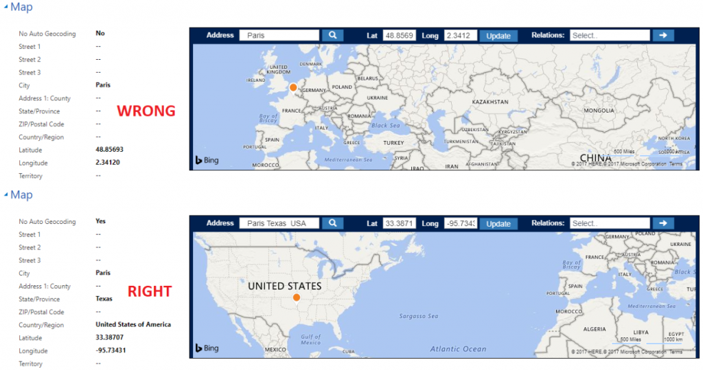
In some cases, places with the same name might be present in different locations.
For example, if you are planning to add Paris city in the state of Texas, you need to ensure that you specify the state and country. Otherwise, the geocoder will geocode Paris, France.
Get started with Maplytics! Download your free trial from our Website or AppSource.
Happy Mapping!


