It was the deciding client meeting, just before the pandemic, that afternoon, and James was struggling to present his data in 15 minutes to the client. He wanted to justify the popularity and sales of his proposed product in the client’s area over the year. However, not being a native to that place, he was unaware of all the postal codes belonging to the region. Ultimately, he decided to display his sales areas separately on different layers in CRM however, felt that the real impact could have been achieved if could have displayed all the sales data together as a single unit.
With the latest update of Maplytics, we have an upgraded feature in place called Multi-search Layer. As the name suggests, this offers multiple layers of search to be performed over the CRM data and display it all together. This feature even allows a selective display to be created out of the multiple layers that have been searched and plotted using various options.
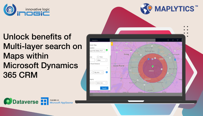
Application of Multi-Layer on Maps for James
If James is equipped with the Multi-Layer search feature, let us see how he could use it. Out of his active accounts, James goes for his first layer of search and selects the state of Texas, USA and plots his clients.

Next, he goes for the second layer of search and draws area with the freehand tool around the region plotted in Search 1 where he knows his clients reside and plots them.

Moving to Search Layer 3, James now uses the Proximity search and plots the only clients who are within the specific radius of his current location.

Benefits of Multi-Layer Feature-
- As we saw in James’ example, he drew the area in the second search layer with freehand tools. Thus, the search alignments can be managed beyond the restrictions of postal codes, county names, postal codes, etc.
- It is not necessary that the clients are all distributed equally under cities or postal codes. Thus, while creating territories using the above options often the clients get heavily aligned into one territory as against another. This creates imbalanced territories for the sales reps to take care and their workload too is unequal then. With multiple searches visible simultaneously, the territories can be re-aligned using freehand distribution and balanced territories can be created as much as possible.
- If certain cities are divided into two reps, the client distribution of those cities gets overlapped between the two reps creating confusion as to who is responsible for which client. When the clients of these cities are plotted over the map together, the client pushpins can be drawn and segregated effectively for the reps without the fear of being overlapped.
- Sometimes, multiple postal codes are assigned to the reps. When these multiple codes are plotted over the map together, it becomes easy to observe the kind of clients that fall into these postal codes. Certain type of clients have a peculiar requirement or a pattern of functioning. Such clients can be visualized easily and separated efficiently to be followed-up by one fixed rep while the rest could be assigned to the others.
These are some situations experienced by our clients. There is much more to Multi-Layer Search and Maplytics. To learn more about Maplytics (5-star rated Preferred App on Microsoft AppSource), its applications across industries, and other amazing functions, do visit our Website or the Microsoft AppSource. For further details, you can hop on to our Blogs, Client Testimonials, and Video Library.
You can write to us at crm@inogic.com for your mapping requirements or a personalized demo.
Happy Mapping!


