
Field operations and management look simple on paper. Assign a few territories, provide sales teams with a list of customers, and expect them to meet their targets. But anyone who has worked in field sales and operations knows this doesn’t work as efficiently.
Teams spend hours navigating between locations, juggling meetings and appointments, and trying to make sense of scattered CRM data. What should be a structured process is actually a daily struggle of inefficiency.
A building material manufacturing client of Maplytics also faced a similar situation.
The Challenge of Managing Growth on the Ground
Our client operates in a highly competitive environment where field teams play a critical role in driving revenue. Their sales operations depended heavily on Microsoft Dynamics 365 to manage customer data, leads, and activities.
However, there was a gap.
While the CRM stored valuable business data, it lacked geographical context. Sales representatives could see lists of accounts and opportunities, but they could not easily understand where these customers were located in relation to each other.
This created multiple challenges-
- Planning daily visits for field technicians and sales reps was time-consuming.
- Sales reps often traveled inefficient routes and wasted time.
- Nearby opportunities were frequently missed.
- Territory coverage was imbalanced.
In simple terms, the data existed, but it was not actionable in the real world.
This is a common problem in CRM systems. Data is structured, but not enhanced visually. However, for field teams, location is everything.
The Need for Location Intelligence
Our client needed more than just CRM management. They needed a way to connect their data with geography.
They required a solution that could-
- Plot customer and lead data on a map
- Help sales teams identify nearby opportunities
- Optimize travel routes between meetings
- Improve territory visibility and planning within CRM
This is where location intelligence became an empowering factor.
When CRM data is visualized on a map, it stops being just information and becomes insight. Teams can see patterns, clusters, and opportunities that are otherwise hidden in rows and columns.
To achieve this, our client implemented Maplytics within their Dynamics 365 environment.
Integrating Maps into Dynamics 365
Maplytics is a geo-analytical mapping solution that integrates directly with Microsoft Dynamics 365, Power Apps, Power Pages, and Dataverse. It allows users to visualize CRM records on interactive maps and take location-based actions.
With this integration, our client’s sales data was no longer limited to lists. Every account, lead, and opportunity could now be plotted geographically.
This simple shift changed how the team interacted with their data.
Instead of asking, “Which accounts should I visit today?”, sales reps could now ask, “Which accounts are near me right now?”
Smarter Planning for Field Teams
One of the biggest improvements was observed in daily planning.
Earlier, planning visits required manually filtering records and estimating distances. This often resulted in inefficient schedules where meetings were spread across distant locations.
With Maplytics, our client’s teams could:
- View all customer locations on a map
- Identify clusters of nearby accounts
- Plan visits based on proximity
This reduced the time spent on planning and increased the number of productive visits per day.
Optimized Routes, Better Productivity
Travel time is one of the highest hidden costs in field operations.
Without optimized routing, sales reps may unknowingly take longer routes, revisit the same areas, or miss opportunities that lie just a few minutes away.
Maplytics addressed this through route optimization within Dynamics 365.
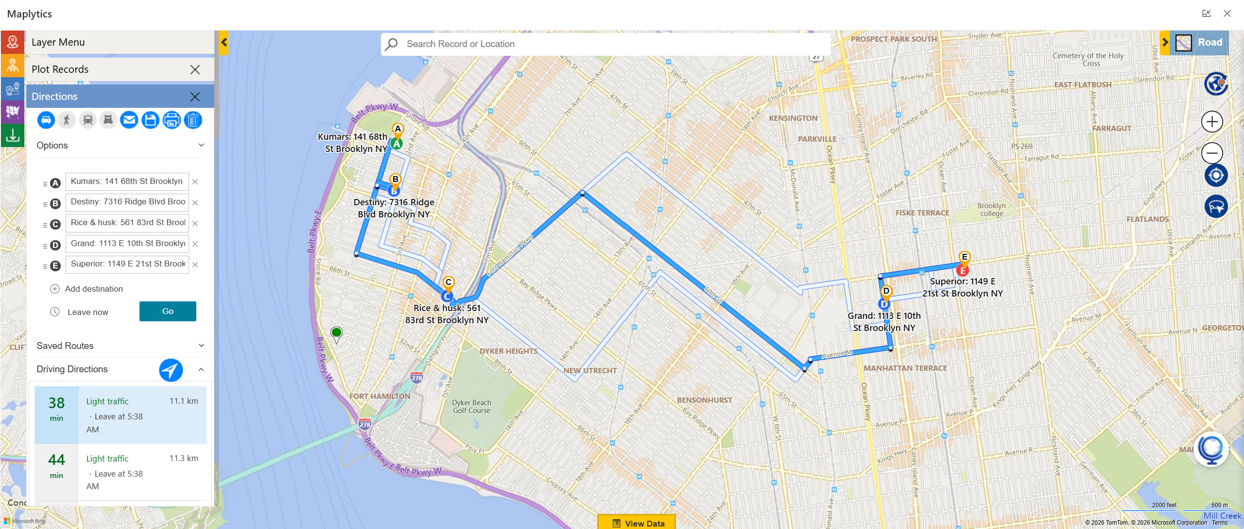 The system analyzes multiple factors such as distance and travel time to suggest the most efficient route between locations.
For our client, this meant:
- Reduced travel time
- Lower fuel costs
- More customer visits in a day
Instead of spending time on the road, sales reps could focus more on meaningful customer interactions.
Better Territory Visibility
Another major improvement was in territory planning and management.
Before implementing mapping, territories were often defined without a clear understanding of customer distribution. This led to some regions being overloaded while others remained underutilized.
With Maplytics, our client could visualize territories directly on the map.
This allowed managers to:
- See how customers were distributed geographically
- Balance workloads across teams
- Avoid overlaps and gaps in coverage
Better territory planning led to more consistent performance across the sales team.
Faster Decision-Making with Real-Time Insights
One of the most valuable outcomes of the implementation was faster decision-making.
With all data available visually, managers and field reps no longer need to rely on reports alone. They could instantly understand:
- Where high-value customers were located
- Which areas required more attention
- How field activities were distributed
This improved both strategic planning and day-to-day execution.
Maplytics essentially turned Dynamics 365 into a location-aware decision system.
Impact on Sales and Operations
The impact of this transformation was visible across multiple areas.
Field teams became more efficient because they spent less time planning and traveling. They were able to visit more customers and respond to opportunities faster.
Managers gained better control over territories and could make data-driven decisions.
Overall, our client saw improvements in:
- Productivity of field teams
- Efficiency of operations
- Customer engagement
- Revenue potential
This aligns with broader industry outcomes where mapping and route optimization help reduce travel inefficiencies and improve business performance.
Our Insight
Our client story also highlighted an important lesson for us.
Most organizations already have the data they need to improve their operations. The challenge is not data availability, but data visualization & usability within Dynamics CRM.
When data is presented in spreadsheets or lists, it is difficult to act upon. But when the same data is visualized on a map, it becomes intuitive and actionable.
Location intelligence bridges this gap.
To Sum Up
Field sales is not just about managing customers. It is about managing time, distance, and opportunity.
Our client’s journey shows how adding a geographical layer to CRM can unlock hidden value in existing data.
With tools like Maplytics, organizations can:
- Visualize their CRM data in a real-world context
- Optimize routes and reduce travel time
- Improve territory planning
- Make faster and smarter decisions
In a world where speed and efficiency define success, location intelligence is no longer optional. It is essential.
What’s more?
If you wish to combine maps, routes, schedules, and real-time updates to make a difference, Maplytics with MapCopilot, its AI assistant, is available immediately for Dynamics 365, Power Apps, Power Pages, and Dataverse. Organizations interested in adoption, 15-day free trials, or personalized demos are encouraged to contact Maplytics’ sales team at crm@inogic.com
For more information, visit our website or Microsoft Marketplace. One can hop onto the detailed Blogs, Client Testimonials, Success Stories, Industry Applications, and Video Library for a quick query resolution. Technical docs for the working of Maplytics are also available for reference.
Kindly leave us a review or write about your experience on the Microsoft Marketplace or the G2 Website.
Sam Kumar
https://www.maplytics.com/Sam Kumar is the Vice President of Marketing at Inogic, a Microsoft Gold ISV Partner renowned for its innovative apps for Dynamics 365 CRM and Power Apps. With a rich history in Dynamics 365 and Power Platform development, Sam leads a team of certified CRM developers dedicated to pioneering cutting-edge technologies with Copilot and Azure AI the latest additions. Passionate about transforming the CRM industry, Sam’s insights and leadership drive Inogic’s mission to change the “Dynamics” of CRM.


